In May, three inexperienced and naive yet hopeful hikers set off to complete the West Highland Way, Scotland’s most iconic long-distance trail and one of the most beloved in the world. Stretching approximately 153 kilometres from Milngavie to Fort William, it attracts over 40,000 walkers each year with its mix of rugged peaks, lochside paths, and sweeping moorland. This blog is a simple day-by-day breakdown of our experience; covering where we stopped, how far we travelled, and the landscapes we moved through.
We’d tossed around the idea of doing the hike but had never seriously planned for it. In the end, it was a spontaneous decision, so we set off with the gear we’d packed for a year of backpacking and picked up a cheap three-person tent, sleeping bags, and travel pillows the day before leaving Glasgow.
Day 1: Milngavie to Drymen
Distance: 26km
We set off from the obelisk in Milngavie and quickly left the town behind, following a well-marked path through gentle farmland, wooded trails, and quiet country lanes. The terrain was mostly flat and easy-going, a good introduction to the days ahead. Along the way, we came across our first honesty boxes; small unmanned stands stocked with snacks, drinks, and essentials for walkers, with a simple payment tin or QR code. A thoughtful touch that set the tone for the trail’s strong community spirit. Rather than stopping in Drymen, we pushed on a little further and set up camp at the base of Conic Hill. Our spot by the river gave us easy access to fresh water and offered our first glimpse of Loch Lomond. Soon after pitching our tent, we were swarmed by midges. This was a harsh but timely lesson in the importance of setting up camp before dusk.

Day 2: Drymen to Rowchoish Bothy
Distance: 24km
We started the day with a steep and chilly climb up Conic Hill, an early challenge that quickly warmed us up in the 6°C morning air. The ascent was tough with heavy packs, but the views from the top were worth every step, offering our first sweeping look over Loch Lomond and into the Highlands beyond. After a quick breakfast stop in Balmaha, we continued along the lochside trail. The path narrowed and became increasingly technical, with exposed roots, uneven rocks, and constant twists. By late afternoon, we reached Rowchoish Bothy, a stone shelter nestled in the forest, open to walkers free of charge. Before settling in for the evening, we braved our first cold plunge in the loch, a freezing but strangely satisfying ritual that became a mainstay. The icy water proved soothing for the many blisters that had already begun to form. Dinner was haggis in a can, my first time trying it, and a fittingly Scottish end to the day. Bothies are basic with no electricity or running water, just a dry place to sleep and often shared with fellow hikers. We spent the night with hikers from the Netherlands and Germany, along with a couple mice.

Day 3: Rowchoish Bothy to Crianlarich
Distance: 26km
We left Rowchoish Bothy early, walking through a stretch of beautiful, quiet woodland as the morning light filtered through the trees. After a few hours, we reached Inversnaid and treated ourselves to scones and coffee, much needed before tackling another long day of rugged lochside trail. The path remained much the same as the day before: narrow, uneven, and slow underfoot, with roots, rocks, and constant twists along the water’s edge. We made a short detour to explore the Doune Byre Bothy, the only other bothy on the West Highland Way. This was a similarly basic but welcoming shelter tucked just off the trail. Later in the day, we passed a small herd of Highland cows grazing lazily near the track, a reminder we were well into the Highlands now. As the midges started to come out again, we pushed on and found a quiet spot to camp just outside Crianlarich, tucked off the path for a bit of peace.

Day 4: Crianlarich to Inveronan
Distance: 25km
Day four brought some of the most breathtaking scenery of the trail so far. We left our campsite outside Crianlarich and soon found ourselves walking through rolling hills and quiet sheep paddocks, with sweeping views that seemed to stretch endlessly into the Highlands. The trail continued to rise and fall gently throughout the day, offering a mix of open farmland, forested sections, and wide moorland vistas. By late afternoon, we began a steady descent into Inveronan, a tiny, peaceful town nestled beside a loch. The town itself was little more than a handful of buildings, but the small local pub stood out, proudly displaying a world map covered in pins placed by visitors from across the globe. We drank pints with fellow hikers from Scotland and Germany, learning new card games and exchanging laughs. After wrapping up, we crossed the road and set up our wild campsite in an open paddock, enjoying the stillness of the area and the novelty of being able to camp so close to the pub.

Day 5: Inveronan to Kinlochleven
Distance: 30km
This was our longest and most challenging day on the West Highland Way. We left Inveronan early, setting out across remote moorland under blue skies. The trail felt wild and exposed, with vast open landscapes stretching in every direction. As we approached Kingshouse, we were rewarded with an incredible view of Glencoe’s rugged peak and its ski resort. After a short rest, we began the climb up the Devil’s Staircase, the highest point of the trail. The zigzagging ascent was steep and demanding, but the views from the top were worth every step. From there, we began the long 7km descent into Kinlochleven, a stretch that tested our knees and patience as the fatigue of the day set in. When we finally arrived, we decided to stay at a paid campsite for the first time on the trail. Showers, a warm meal, and a proper place to relax felt like pure luxury. We ended the night swapping stories with other hikers we’d been bumping into along the way; now familiar faces with shared experiences.

Day 6: Kinlochleven to Fort William
Distance: 24km
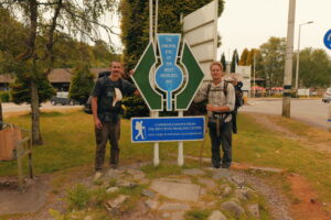
We had assumed our final day would be relatively easy, shorter in distance and with the end in sight, but it turned out to be anything but. Leaving Kinlochleven, the trail climbed steeply and immediately tested our tired legs. The quick ascent did offer one reward: a spectacular view looking back over the town, glowing softly in the morning light. From there, the path levelled out somewhat but became increasingly rugged. The loose, rocky terrain made each step feel heavy and unstable, revealing just how much wear our bodies had taken over the past five days. We moved steadily through the wide, exposed glen, with the looming presence of Ben Nevis hinting that we were nearing the finish. Eventually, we began a long, jarring descent toward Glen Nevis, where the trail transitioned into tarmac for the final stretch into Fort William. Those last kilometres felt surreal, equal parts painful and euphoric, as we reached the official end of the West Highland Way, tired but incredibly proud.
We can’t recommend the West Highland Way enough; it’s a journey through some of the most diverse and dramatic landscapes Scotland has to offer. If you’re planning to tackle it, pack light, choose food that will properly fuel long days, and take the time to appreciate the history beneath your feet. Thanks to Tom Hunter’s original vision in the 1970s, this trail continues to connect walkers with Scotland’s natural beauty in a truly unforgettable way.
Photography throughout this post is courtesy of Brian Matthews, whose lens captured the wild beauty and atmosphere of our journey through the Scottish Highlands.
beautiful memories so beautifully written & captured — great stuff 🙌🏼
Thanks Brooke! Surely you and the boys are keen on joining us for a Euro summer? 😉
What a great adventure. Are you heading over to outer Hebrides? These are my favourite beaches in the world.
No we aren’t unfortunately… I recently saw them online, and they look incredible!